There Is No Cat

The alternative to flowers!

Monday, November 27, 2006

The survey says....

Defense Mapping Agency Survey Mark

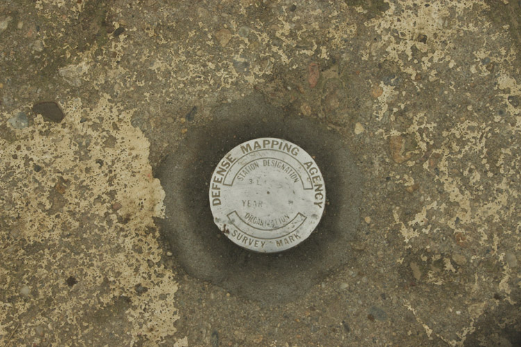
I stumbled across (well, not literally, and good thing or I would have wound up tumbling down into the water, I think) this metal disk embedded in some rock across the street from a lighthouse in Woods Hole, Massachussetts, when we were on Cape Cod recently. The Defense Mapping Agency no longer exists, having been subsumed into the National Geospatial-Intelligence Agency, and there's not much information on the web about these survey marks, but they must have been important for someone to go to the trouble to place one in the rocks on the shore here. Near as I can tell, these were part of an effort to map the Americas for use in weapon navigation systems (although the data were used for many other things as well, that seems to be the most likely explanation for the impetus behind the effort).

Anyway, it caught my eye, and I thought it was a photo of an interesting object.

Tags:

Posted at 11:44 PM

Comments

Note: I’m tired of clearing the spam from my comments, so comments are no longer accepted.

Would you be at all surprised to learn that there are people who hunt and log these things?

www.geocaching.com/mark/

Posted by pjm at 4:04 PM, November 28, 2006 [Link]

I recall seeing some movie or tv show or something that described how the maps were, in a sense, a set of coordinates that are "pinned" to the earth on those survey marks.

In a similar vein, Doc M, who worked on the Shuttle Radar Topography Mission, describes trips to remote areas of Australia placing what he calls "corner reflectors" -- something that has a known point (via GPS, I believe) that is then captured on the shuttle flyover (reflectors will produce known radar response of some sort), and that's one of the things that they used to calibrate the maps. Defense Mapping became in an interim state, NIMA--they were co-sponsors of that mission. I guess that's what got subsumed into the NGIA entity you name.

Doc M is headed out to the Mohave desert tomorrow where a helicopter has been fitted with a special radar that will flyover known territory to see how it picks up this and that kinda terrain--flat lakebeds, dunes, and lavafields. Happily, all of those can be found within a couple hours drive of the greater Los Angeles area.

He's gone on a couple of pre-flighttest scouting tests there, and at one point described the SRTM results as being more accurate than [insert some other Digital Elevation Model topo map here], as SomeOtherDEM was off, slanted at an angle which renders the whole thing useless for their purposes. But the SRTM results are not high enough resolution and too noisy overall to use. And so it goes. They drove over a dry lake bed with a GPS lashed to the roof of a van to get some baseline coordinates. Fine for flat lake bed, not so good for lavafields. Sand Dunes don't stay still long enough for maps to be of any use. All in all, it's kinda similar to those survey marks for making this single-use, highly specialized radar data map.

The radar that they're testing is part of the landing system for a future Mars-bound spacecraft. So, er, uh, yeah. Survey marks and their various uses. How fun it is!

Posted by Susan Kitchens at 5:02 PM, November 28, 2006 [Link]

PJM, not only am I not surprised, I'm even less surprised that you would know about this. :-)

Susan, yes, NIMA renamed themselves NGIA at some point. The URL I link to is still nima.mil, but the web site is all about NGIA. They have a history PDF that details the merger of DMA and some other agency to form NIMA, which was then renamed NGIA.

You're so lucky to be dating a rocket scientist.... :-) My only connection with rocket scientists is that my representative in Congress is one (so the bumper stickers say....)

Posted by ralph at 5:38 PM, November 28, 2006 [Link]

Trackbacks

This site is copyright © 2002-2024, Ralph Brandi.

What do you mean there is no cat?

"You see, wire telegraph is a kind of a very, very long cat. You pull his tail in New York and his head is meowing in Los Angeles. Do you understand this? And radio operates exactly the same way: you send signals here, they receive them there. The only difference is that there is no cat."

- Albert Einstein, explaining radio


There used to be a cat

[ photo of Mischief, a black and white cat ]

Mischief, 1988 - December 20, 2003

[ photo of Sylvester, a black and white cat ]

Sylvester (the Dorito Fiend), who died at Thanksgiving, 2000.


Stylesheets


This site is powered by Missouri. Show me!

Valid XHTML 1.0!

Valid CSS!

XML RSS feed

Read Me via Atom

new host

Me!

Home Page
Resume
Married
Photographs
Flickr Photostream
Instagram Archive
Twitter Archive

last.fm

There Is No Cat is a photo Ralph Brandi joint.


Archives

Search


Family Blogs

Geneablogy
Jersey Girl Dance
Awakening
DullBlog
Mime Is Money

Blogs I Read

2020 Hindsight
AccordionGuy
Adactio
Allied
Apartment Therapy
Assorted Nonsense
Backup Brain
Burningbird
Chocolate and Vodka
Creative Tech Writer
Critical Distance
Daily Kos
Dan Misener likes the radio
Daring Fireball
Design Your Life
design*sponge
Doc Searls
Edith Frost
Elegant Hack
Emergency Weblog
Empty Bottle
Five Acres with a View
Flashes of Panic
Future of Radio
Groundhog Day
Hello Mary Lu
iheni
Inessential
Interllectual
Jeffrey Zeldman Presents
Jersey Beat
John Gushue ... Dot Dot Dot
john peel every day
JOHO The Blog
Kathryn Cramer
Kimberly Blessing
La Emisora de la Revolucion
Lacunae
Loobylu
mamamusings
Medley
mr. nice guy
MyDD
Orcinus
oz: the blog of glenda sims
Pinkie Style
Pinkie Style Photos
Pop Culture Junk Mail
Seaweed Chronicles
Shortwave Music
Slipstream
Talking Points Memo
The Unheard Word
Tom Sundstrom - trsc.com
Typographica
Unadorned
Vantan.org
WFMU's Beware of the Blog